
|
Sailing from Bodrum to Marmaris |
|
|
|
Archaeology Museum. It is now a showcase for the marvelous finds of antiquity discovered in the area, and An impressive medieval castle built by the Knights of marvelous finds of antiquity discovered in the area, and is recognized as a worldwide pioneer in the field of underwater archaeology.on the north shore of the Guff of Gökova, was the home of the first "Blue Voyager", Cevat Sakir Kabaagaç or the "Fisherman of Halikarnas". It is the undisputed "hot-spot" of the Aegean Coast. This swinging, singing, dancing town, with its bohemian atmosphere, gathers together Turkeys artists, intellectuals and lovers of the good life.
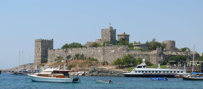
An impressive medieval castle built by the Knights of Rhodes guards the entrance to Bodrum's dazzling blue bay, in which the Aegean and the Mediterranean
Seas meet. The Bodrum Castle now houses the Museum of Underwater Archaeology. Known in ancient times as Halicarnassus, Bodrum is the birthplace of Heredotus and
the site of King Mausolus's Tomb (4th century B.C.), one of the Seven Wonders of the ancient world. The Bodrum Karaada Marina is one of the loveliest and best-equipped marinas in the region. A yachting tour of the Gulf of Gökova starts in Bodrum. The translucent and deep waters of the Gulf on the southern shore of the Bodrum Peninsula vary from the darkest blue to the palest turquoise, and the coastline is thickly wooded with every hue of green. In the evening, the sea reflects the mountains silhouetted against the setting sun, while at night it shimmers with phosphorescence.
While one may sail directly from Bodrum to Knidos and Tekir cape in the course of one's Blue Voyage, it is also possible to proceed by following the bay indented coastline of the gulf of Gökova. Vessels setting out from Bodrum to visit Gökova pass Karaada, famous for its hot springs and known in ancient times as Arkanessos, and then Pabuç Cape and arrive at Kargicik Bay. Before reaching here one sees a small island called Kistak that one may sail past on either side though care must be taken of a reef to its north. Kargicik is a large and fine bay. Yachts may anchor on its southern side. Taking a swim in its crystal-clear waters is a special delight.
Leaving Çökertme, one arrives at Çamalti Bay, the jetty for Ören where one may visit the ruins of Keramos. Keramos is 48 km from Milas and one can reach it by road as well. The modern town of Keramos is located on the ruins of Keramos. A city of Carian origin, the date of its foundation is unknown though we know of its existence from the 5th Century onward because it was a member of the Delian League. Ruled by the Persians and then Alexander and passed variously through the hands of Rhodes, Rome, and Byzantium. |
|
At Keramos today one notices sound city walls and their gates remaining from Hellenistic times here and there. The ancient acropolis was between Mese Kayasi and Çamtepe.
Outside the village at a place called Bakicak is a marble platform surrounded by a wall. The three blocks visible are all that remains of the foundations of the
temple of Zeus Khrsaoreus. There are also ruins of another temple, called Kursunlu today. This temple, located at the foot of the acropolis hill outside the city
walls, is in a very ruined state. There are also remains of many Roman and Byzantine buildings at Keramos whose functions can no longer be discerned, though one of them was
probably a basilica. On the southern side of the city is a Byzantine church.
Leaving Ören and proceeding about 10 km past Karaburun, one reaches Akbük Harbor. Situated at the foot of thickly wooded mountains, Akbük Harbor is a very good harbor that is sheltered against the western and northwestern winds. There is a cafe and a restaurant here and one may anchor on the jetty before the harbor or else west of it.
From here one may proceed to Gökova Quay, the extreme end of the gulf of Gökova. Encircled by emerald-green mountains, one never tires of the beauty of Gökova. There are two concrete jetties here and one may anchor before the park. Proceeding from here overland to Marmaris, one has a magnificent view of Gökova. Six hundred meters below Sakar rock on the Gökova highway we find the ancient city of Idyma. Descending by means of a winding road, the city walls of the acropolis are visible here and there on the steep slopes. Below them are the remains of a medieval castle. Among the cliffs on the slope one can see rock tombs that resemble temples from the 4th Century B.C.
Gasoline and water are available at Gökova jetty and the Forest Administration also has a number of facilities here. From Gökova jetty one may proceed to Cleopatra Island, which can also be reached by car. A road that branches off the Marmaris highway comes down to the jetty at the village of Gelibolu and from there you can get to Sedir Island in a rented boat. Boats are also available for rent in Taçbükü. On a hill east of Kizilkaya at the village of Gelibolu is the ancient city of Kallipolis, from which the present-day name of Gelibolu was derived. The ancient and medieval castles here reflect the lengthy past of this region.
At the southern most end of Karaca harbour, three or four miles from Sedir Island, one comes to Sögüt Harbor before which is an island called Karacaada. This pine covered harbor is a place of marvelous beauty. A stream called Incedere discharges into Sögüt Harbor and in the mouth of the creek is a jetty. To the east is another jetty. This harbor is connected by road to Marmaris. |
|
After Datça we come to broad Kuruca Harbor, which is located between the Adatepe peninsula and Çiftlik Island. Leaving Çiftlik Bay where there is a holiday village, we pass Adatepe Cape and arrive at Kuruca Cove. From here we pass Kuruca Island and Bozan Cape reaching Bencik, at the narrowest part of the peninsula. Bencik stretches inland 3 km, almost as if attempting to break through to the other side. It is a great pleasure to wander about these coves and inlets drinking in the loveliness of their blues and greens. The beauty of the scenery cannot be adequately told and must be experienced to be appreciated.
At the entrance to this bay is Dislice Island. During the Persian invasions in 540 B.C., the Knidians sought to dig a canal between Bencik and Küçükçati on the other side as a defensive measure against the Persian armies and turn their city into an island. An oracle was consulted who reportedly said "If the gods had wanted, they would have made your city an island. Do not pierce the isthmus."
Where upon they surrendered to the Persians-After leaving Bencik, we enter Hisarönü harbor where the ruins of Bybasos are to be found. On the southeastern side of the gulf is Keçibükü Bay, inside of which there is an island. Keçibükü is the best anchorage. On the island are the ruins of a fort. A bit inland from this bay is the village of Orhaniye and the ruins of Bybasos are located on a hill above the village. The ruins of city walls, some from medieval, some from Hellenistic times can be seen here and there within the forest on this steep and rocky hill. At a place called Pazarcik on Eren mountain south of the village of Hisarönü was the ancient city of Kastabos. After leaving Hisarönü Harbor, we enter Delikliyol Harbor and Selimiye Bay. In the bay is a section called Buruncuk that is suitable as an anchorage. A bit inland from this bay near the village of Selimiye is the ancient city of Hyda. Leaving Selimiye Bay we sail pass a number of small islands Kameriya, Koca, Uzun, Topan, and Kargi after which we reach the last of the inlets in the Hisarönü gulf, Dirsek. To enter this one needs to sail round Kargi Island.
On the southern side of Dirsek Cape are the underwater remains of an ancient quay. Leaving Dirsek and passing Agil Cape we reach Atabol Cape, the sea of which is full of
rocks. Sailing carefully pass them one reaches the Sombeki (Bozburun) gulf. Passing between Kizilada and Zeytin Ada and leaving Kiseli Island to one's port side,
we enter Bozburun Harbor. Bozburun Is a famous for its boatyards and the ruins of ancient Tymnos are here. The eastern side of Kizil Island immediately before
Bozburun as well as the southwestern side of Kiseli Island are both suitable as anchorages. One leaves here sailing pass Sögüt Island and enters Sögüt Harbor. There are many
Islands here.
Continuing on our Blue Voyage we fill our sails with wind and rounding Karaburun come to Bozukkale, some two and a half miles beyond. Every yacht is sure to call at Bozukkale. In ancient times there was a shipyard here. Entering the bay, the citadel walls of the ancient city of Loryma that used to be here can be seen on the western side. The walls facing the entrance to the bay are 2.24 m thick and 320 m long and they enclose an area measuring 274 sqm. At one time there were two projecting towers at the corners of the citadel and nine rectangular towers as well. Today only the projecting tower on the north remains. Four of the five gates in the wall faced north. There are two cisterns here carved partially into the rock, one on either side of the wall. On the acropolis hill east of the jetty is another wall built of rectangular and multi-angular stone.
An inscription on the wall of a cave at the foot of the hill extending along the seashore announces that it is prohibited to remove offerings that have been dedicated to a sacred place. On some maps this harbor is called Aploteka.The harbor is sheltered against severe weather conditions. During the Peloponnesian wars, Athenian ships concealed themselves here for a while. The Athenian commander also used the place as a rendezvous point before the battle of Knidos in 395 B.C. In 335 B.C., Demetrios, son of Antigonos, built up his fleet here.
The harbor at Bozukkale was also used during Roman and Byzantine times and by the Knights of Rhodes as well. On the southern side of the Loryma peninsula there are heaps of stone consisting of four or five blocks set atop one another. They may have been the foundations of altars. Two miles after Bozukkale is Serçe Harbor. The entrance to Serçe Harbor is like a giant door made of huge boulders. The western side of the harbor consists of steep slopes and rough, rocky terrain. One should sail with the Çatal Islands to one's south or else between them: the passage between the mainland and Çatal Island should not be used. Before the southern promontory of the bay is a small reef that is very dangerous and many ships have been lost throughout history on them.
Serçe Liman. In 1025 A.D. in the month of September, a two masted ship measuring 15 m. in length and 5.13 m. abeam and displacing 30-40 tons set out with a cargo she took on
at one of the harbors in the rich Fatimid countries. Just as she rounded Bozukkale however she was caught in a storm and tried to take refuge at Loryma but hit a rock and sank in
32 m. of water. Between 1977-79, Professor George Bass and a team of Turkish and American underwater archaeologists excavated the wreck. Besides a cargo of pottery, a large number
of works of glass were brought up.
After leaving Serçe Harbor, we come to the lovely bay of Ince Island located north of the Ince Island Cape. Besides the extraordinarily beautiful scenery here one also notices medieval ruins. The olive covered hills afford protection against the winds. Leaving here, we come to the broad harbor of Çiftlik. One may pass along either side of the island before the harbor and drop anchor. There is a holiday village here.
Setting sail from Çiftlik Harbor we pass Kadirga Cape with its light and enter Kadirga Harbor. There are possible anchorages southwest of Kadirga Harbor and
also in the inlet to its northwest. This bay is quite close to Marmaris, and the daily tour boats leaving Marmaris also call here so the place is always quite active. After this
bay comes Kumlubük and we can tie up onto the jetty in this bay where the tour boats from Marmaris take out time for lunch.
After leaving Turunç we enter Marmaris Harbor. On the west is the district of lçmeler where there are more hotels and motels. Before lçmeler is Keçi Island. There are other islands in the bay including Nimara, which is actually connected to the mainland by a low isthmus called Yalanci ("False") channel, and the islands of Yildiz and Cennet. Before the peninsula is tiny Bedir Island.
Situated on a bay, backed by rugged pine-clad mountains, Marmaris is one of the most attractive maritime parklands, ideal for water sports and sailing. It makes an excellent starting point for the "Blue Voyage" tour of the Aegean coastline. In May, the Marmaris Yacht Charter Show provides an opportunity to meet the yachts' captains and crews. With plenty of provisions aboard, you set sail in the craft of your choice and languidly explore the spectacular beauty of southern Turkey.
In Marmaris, sample the typical Turkish cuisine in one of the marina restaurants and drink raki, anisette, the traditional Turkish way, over ice and diluted with water. Later stroll along the brightly lit and palm-lined promenade and indulge yourself at one of the ice cream vendors. Energetic entertainment at a lively bar or dancing until dawn at a sophisticated disco can end a perfect day.
There are many good buys in Marmaris' boutiques, colorful bazaars and markets. You can find excellent leather and suede goods, copper and brassware, jewellery and objects
carved of onyx. Turkish carpets, textiles and embroidery make good handcrafted souvenirs, and the locally produced pine -scented honey called çambali is superb.
Near Marmaris at Içmeler, the hazy mountains of the interior slope down to sandy beaches. Under blue skies, the clear sea is ideal for all types of water sports. Many find this area so irresistible that they stay longer than originally planned. And there are some excellent accommodations here, in which you can prolong your contact with nature. |